The visiting itineraries
Itinerary 1 (indicative)
Pattada - Monte Lerno - Lake of Pattada
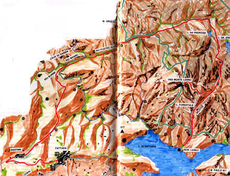
From Pattada you get to Bantine. After a few kilometres you
reach, on a dirt road, the state-owned area at the feet of Mount
Lerno. From the sand quarry on the river Riu Mannu continue
toward the river Riu Fustes Alvos, still on the dirt road cross
the bridge over the river and enjoy the spectacle vegetation
offers charged with great suggestion.
* - The indicative itinerary is
evidenced by the red line
Itinerary 2 (indicative)
Pattada - Sololche - Monte sa Muzzere
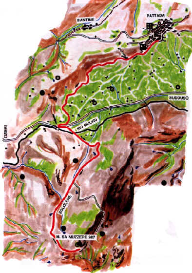
You start from an ancient railway station, in the area of which
there is an important dairy, a service station and a hotel with
restaurant. On this asphalted road go in the direction of the
high areas of the Goceano. After a small piece of road, a fork
takes you to the wood of Sololche, having a park which has been
installed recently. At a short distance there is the area of the
peak Punta sa Muzzere, a wide panorama point facing a landscape
similar to the more important one of Mount Lerno for certain
aspects.
* -
The indicative itinerary is
evidenced by the red line
Freely taken from the publication
MONTE LERNO AND SURROUNDINGS- Guides and itineraries of Sardinia
- edited by I. Camarda and S. Diana - n. 3 - Carlo Delfino
Editore - Roma 1992
Photographic illustrations by I. Camarada, G. Niedda - P. Melis