| GIZA,
ORION AND THE PLANETARY DESIGN |
| The search on the enigma of Giza has known decisive carrying out with the fundamental intuition of Robert Bauval, according to which the three Pyramids of Khufu, Khafre and Menkaure represent the three stars of the Belt of Orion, just as the Nile represents the Milky Way. I will have necessarily to give for discounted the acquaintance of the details of the theory of Bauval (then developed with Graham Hancock); I limit myself to point out the salient aspects of the stellar correlation supported by Bauval and Hancock: the perfect correspondence between sky and earth would have taken place in 10.500 a.C., at the beginning of the age of the Lion (represented on earth by the Sphinx), when Orion was at the lowest point of its precessional cycle and therefore it was at its "first time". Moreover, at the dawn of the spring equinox in the years around 10.500 a.C., it happened that not only the Great Sphinx faced the rising of the sun in the constellation of the Lion, but also that the Belt of Orion culminated at the meridian in the same moment. It was just this heavenly configuration, so powerful and evocative, to induce Bauval and Hancock to identify the First Time of Orion with the First Time of the gods (Zep Tepi) who reigned, according to the myths, at the beginning of the egyptian civilization. |
| The correspondence between sky and earth |
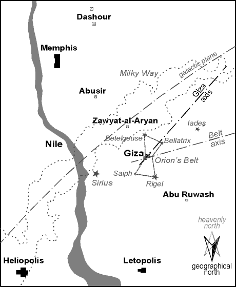
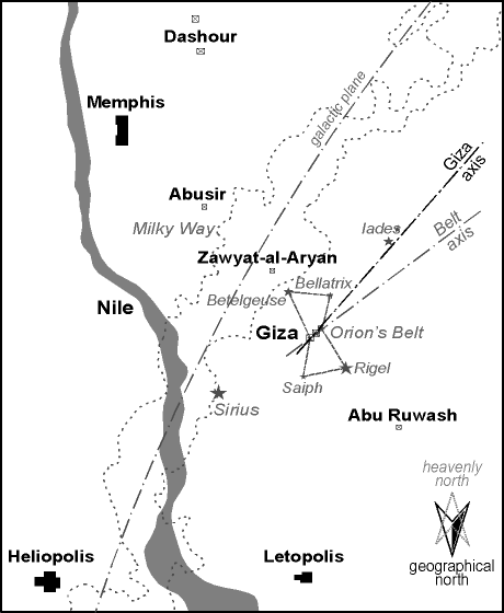
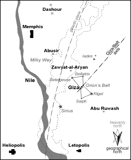
| In truth it is just on this last aspect that Bauval and Hancock fall in error. The perfect correspondence between sky and earth came true not in 10.500 a.C., but approximately 1500 years before, around 12.000 a.C. In order to verify this matter we must arrange two maps: an astronomical map (centered on the heavenly region of Orion) and a geographical map (limited to the terestrial region surrounding Giza, that is to say the area of the necropolis of Memphis); then we must superpose the two maps, and this is a geometrically complex operation that I am forced to fly over for the sake of brevity. I will simply say that, put some premises, it is possible to superpose the two maps making Alnitak coincide with the Pyramid of Khufu and aligning the heavenly meridian with the geographical one. Now, the result of this operation is not univocal, but it changes with the age to which the astronomical map refers, just as the aspect of the sky changes accordingly to the precession of the equinoxes. In fact, while the geographical meridian on the terrestrial map is fixed (and correspondent to the axis of the Pyramids, which are aligned very precisely to the cardinal points), the orientation of the heavenly meridian on the astronomical map changes accordingly to the precessional cycle. What is the result? If we use first an astronomical map of 4500 a.C. (presumptive age of the Great Pyramid), secondly one of 10.500 a.C. (First Time of Orion) and finally one of 12.000 a.C. and we superpose them upon the geographical map, we achieve the results represented in picts. 1, 2 and 3. From the comparison of these three images it can be observed that the firmament seems rotating counter-clockwise around Alnitak going back in time: if in the first case (presumtive age of the Great Pyramid) the Belt of Orion appears remarkably off the axis in respect of the Pyramids, in the second case (the First Time of Orion) the error appears much smaller; yet only the astronomical map of 12.000 a.C. enables the perfect coincidence of the axis of the Belt with the axis of the three Pyramids of Giza. |
Fig. 1 - The heavenly region of Orion (age 2.500 a.C.) superposed upon the necropolis of Memphis |
Fig. 2 - The heavenly region of Orion (age 10.500 a.C.) superposed upon the necropolis of Memphis |
Fig. 3 - The heavenly region of Orion (age 12.000 a.C.) superposed upon the necropolis of Memphis |
| The First Time of Sirius |
| If the hypothesis of the stellar
correlation is valid, it is simply unthinkable that Sirius — the most important star for
the egyptian civilization — does not have a place in the scheme; but on this aspect the
theory of Bauval and Hancock is rather inadequate, since Sirius does not play any role.
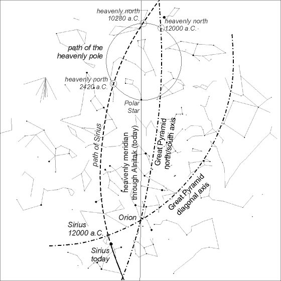
Therefore, at this point, the problem is discovering how Sirius become part of the game. Let's go back to pict. 3, which represents the superposition of the geographical map of Giza upon the astronomical map of 12.000 a.C., and let us pay attention on the diagonal axis that goes from the north-east angle to the south-west angle of the square of the base of the Great Pyramid: this axis, extended south-west, passes close to the other two Pyramids, while extended north-east it passes near Sirius. Just this is the key of the problem: the proper motion of Sirius is remarkable, which means that its position in respect of the other stars changes with the time (more than one degree in 3000 years). Now, if we check what was the position of Sirius in 12.000 a.C., we find out that the star was placed just on the diagonal axis that goes from the Great Pyramid in the superposed map (see picts. 4 e 5). It is extremely improbable that a correlation so precise and symbolically pregnant can simply be fruit of the chance, especially if we consider also what has been discovered by Bauval and Hancock on the stellar religion of the ancient egyptians. But there is also another element that makes us be inclined to the intentionality of this scheme, and it is that the date of 12.000 a.C. is very close to the "first time" of Sirius: to be more precise, approximately 13.850 years ago the star was at the minimal height on the horizon within its precessional cycle. In other words, the date of 12.000 a.C. corresponds to the First Time of Sirius just like the date of 10.500 a.C. corresponds to the First Time of Orion |
Fig. 4 - The alignment of Sirius with the diagonal axis of the Great Pyramid, in 12.000 a.C. |
Fig. 5 - The horizon of Giza at the dawn of the spring equinox, in 12.000 a.C. |
| The dawn of Horus |
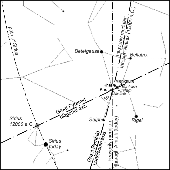
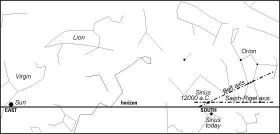
| There is one more reason that makes
absolutely peculiar the date of 12.000 a.C.: Sirius, in that remote age, was crossed also
by another alignment, that one defined by the stars Rigel and Saiph, the "feet"
of the heavenly figure of Orion (see pict. 6); but it is not all.
Let us imagine to be at Giza, at the dawn of the spring equinox, 14.000 years ago. Let us
turn the look at the southern sky. In that precise moment, Sirius culminates at the
meridian, as high on the horizon as 1,15° approximately, while Rigel and Saiph were at
its right and at the same height on the horizon: the Sirius-Rigel-Saiph alignment is
therefore parallel to the horizon, so that the divine figure of Osiris (with whom Orion is
identified) appears straight and nearly seems walking on the line of the horizon, beside
his consort Isis (with whom Sirius is identified) just when she crosses the heavenly
meridian. The powerful mythological and astronomical symbolism includes also another fascinating aspect: the First Time of Sirius happened just in the middle of the precessional age of the Virgin (that goes approximately from 15.050 to 12.900 years ago); but just like the Sirius star, also the constellation of the Virgin is identified with the goddess Isis. Therefore an observer placed at Giza, at the dawn of the spring equinox in 12.000 a.C., turning its look at east would have seen the heavenly Virgin (assimilated to Isis) together with the Sun on the horizon, while turning its look 90° right, at south, he would have seen Sirius (assimilated to Isis too), at the culmination, grazing the horizon as well; turning its look some more right, he would have seen Orion (assimilated to Osiris) "standing" on the horizon, as high as Sirius. In this moment, moreover, the axis of the Belt of Orion crossed Sirius exactly. Now, I would like to remind the reader a ritual expression that used to be pronounced during the cerimonial of interment of the defunct Pharaoh, in the context of a rite that meant to evoke symbolically the divine connection between the deceased (assimilated to Osiris) and the star Sirius (the goddess Isis). The above mentioned expression (passage 632 of the Texts of Pyramids) recites like this: "Your sister (wife), Isis, comes to you overflowing with love. You have placed her on your penis and your sperm gushes inside her, ready like Sirius, and Horus-Sopd has come to you like Horus who is in Sirius ". Well, if we assume that the axis of the Belt of Orion symbolizes the penis of Osiris and that Sirius symbolizes the womb of Isis, the entire heavenly configuration above described seems to be an evident representation of the insemination of Isis by means of Osiris, with the consequent birth of Horus-Sun, carried to light by the heavenly Virgin. |
Fig. 6 - The heavenly northern hemisphere: shown the path of Sirius and the superposition of the north/south and diagonal axis of the Great Pyramid |
| The globe sky-earth |
| The principle of the stellar
correlation, postulated by Bauval, can be considered reasonably demonstrated, because of
the elements above stated. Seeding many clews with masterly skill and knowledge, the
ancient planners have lead us to trace the superposed map of Giza and Orion, they has
shown us the stellar clock of Sirius aimed at the date of 12.000 a.C., they has revealed
us the powerful heavenly configuration which took place at the dawn of the spring equinox
of that remote age. Still, the principle of the stellar correlation has not been but the
instrument with which defining the language of the communication and suggesting in what
direction to go on. In my opinion the suggestion is evident: developing the idea of
superposing, one upon the other, the heavenly and the terrestrial maps, extending the
operations to the heavenly vault and to the terrestrial surface in their totality. Just this has been, since the beginning, my instinctive conviction. Following the thread of such reasoning, I imagined the heavenly sphere like a glass globe which had to be superposed upon the terrestrial globe; Alnitak in the Belt of Orion and the Pyramid of Khufu at Giza had to represent, of course, the points of collimation of the two spheres. Made the two points coincide, then the heavenly sphere had to be rotated around this sort of hinge, until the perfect alignment between the geographical meridian and heavenly meridian of 12.000 a.C. (the same alignment shown in pict. 3) was reproduced. I decided to call that unusual map of the world "sky-earth globe". In truth, the first element that came out was an evident incoherence: I could expect a perfect coincidence of the poles of the two spheres at the date of 12.000 a.C. (if the principle of the correlation was valid), instead the poles in the sky-earth globe did not coincide at all, neither in that date nor in any other. Therefore I began to think that, perhaps, the message contained in the scheme consisted just in the incoherence found: if in the sky-earth globe the poles did not coincide, perhaps that was because we were using the present order of the terrestrial globe; but what about the past? Was it possible that once the geographical poles were situated elsewhere, and just in the spots required by the coherence of the sky-earth superposition scheme? What we needed was a movement of the poles, happened some time in the past, such to break the initial coherence of the scheme; and then I wondered if a theory which described phenomena of that kind existed in the scientific culture. Well, such a theory did exist, and it was well known from some time, even if at the margins of the academic circle. It was at that point that my search met the theory of Charles Hapgood about the shiftings of the lithosphere. He maintains that the lithosphere, in certain conditions, can globally shift in respect of the fluid mantle below, in such way that regions first situated near the poles then, after the shifting, are placed at lower latitudes, and vice versa. We can imagine an event of that kind resorting to the image of an orange peel that gets separated from the inner content of the fruit, being so able to rotate independently from it. The consequences of such an event, that according to Hapgood should accomplish in a few thousands of years or maybe less, are evident: immense climatic upset, sudden thaws and dramatic glaciations, elevation of the sea level, alteration of the coastal lines, disappearance of entire regions, mass extinction of animal and vegetable species. The interesting matter is that all above said could have happened the last time no more than 12.000 years ago, when the last big, sudden mass extinction took place. Hapgood went so far as to establish that the lithosphere should have undergone three shiftings within the last 80.000 years. Until about 80.000-75.000 years ago the North Pole was situated in the District of Yukon, in Canada, approximately at lat. 63° N long. 135° W (for convenience of exposition I call 1 such position), then the lithosphere underwent a shifting that placed the North Pole in the Greenland Sea, approximately at lat. 72° N long. 10° E (I call 2 such position). This situation has kept until about 55.000-50.000 years ago, when a new shifting placed the North Pole in the Hudson Bay, again in Canada, approximately at lat. 60° N long. 83° W (I call 3 such position). Finally, around 17.000-12.000 years ago it occurred the last shifting, that moved the Pole from the Hudson Bay to the present position (I call 4 such position). |
| The planetary design |
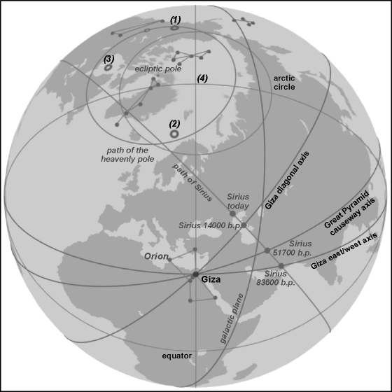
| My idea was to represent these three ancient polar sites on the globe sky-earth. As soon as the operation was accomplished, it did not take long for me to realize that the most "impossible" correlation shown itself to my eyes: all three ancient polar sites in the northern hemisphere (and obviously the same thing happens in the southern hemisphere) are situated very close to the circle that represents the path of the heavenly poles (see pict. 7)! The average error is about 2,83°, that is some more than 300 km, too small a value to believe simply in a fortuitous case. But not only this: the path of Sirius passes not far away from two of these sites, providing also a visual image of the migration that the North Pole performed from the Greenland Sea to the Hudson Bay. I had discovered the "planetary design": with that name I decided to call the correlation scheme between the globe sky-earth and the shiftings of the lithosphere. |
Fig. 7 - The sky-earth globe: shown the path of the heavenly pole, the path of Sirius, the ancient polar sites and the axis of Giza |
It is meaningful, in my opinion, that
there are three precise dates when the coherence of the planetary design is perfect (that
is, it occurs the coincidence of the heavenly poles with the terrestrial poles): these
dates are 101.650 before present (coincidence around position 1), 64.550
b.p. (coincidence around position 2) and 29.500 b.p. (coincidence around
position 3), and such dates are each in the middle of the geological ages
beaten out by the shiftings of the poles described by the theory of Hapgood. But the
planetary design offers more. Let us consider the configuration of the site of Giza, the
main axis of which be pointed out: the axis north/south and east/west, the
north-east/south-west diagonal axis (the one that crosses Sirius in 14.000 b.p., see again
picts. 4 and 5), and finally the axis defined by the
causeway that leaves a structure beside the base of the Great Pyramid and goes
approximately in the direction 15° north of the east. If we check on the sky-earth globe
the intersections of such axis with the path of Sirius we discover that:
We can see that ther is an amazing agreement with the dates pointed out by Hapgood for the shiftings of the poles (considering also the comparative uncertainty that affects the geological data). Now, what I would like to remark is this: maybe the theory of Hapgood is by itself wrong; and maybe the theory of the stellar correlation, fully expressed in the sky-earth globe, is by itself wrong too. But is it possible that two theories, one independent from the other, are both wrong and still provide elements which are substantially concordant? Yes, of course it is possible; but as well improbable as the case of two liars, who never met, who invent two tales perfectly coherent one with the other. |
| A world-wide geodetic network |
| There are others, astonishing proofs
that confirm the planetary design. Little above I have pointed out that the path of Sirius
approximately represents the "jump" that the North Pole performed from the
Greenland Sea to the Hudson Bay. Following the path of Sirius on the sky-earth globe I
noticed that it passed close to ancient Teotihuacan, in Mexico. Surprised by this case, I
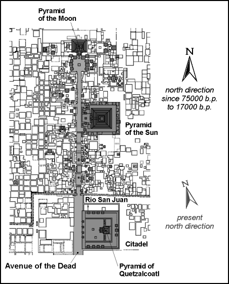
wanted to check if there were any relationship between the most famous Avenue of the Dead
of Teotihuacan and the two ancient polar sites: well, the axis of the Avenue of the Dead
aims at both with excellent approximation; in other words, the axis of the Avenue points
at that direction which has been the north/south direction for nearly 60.000 years, until
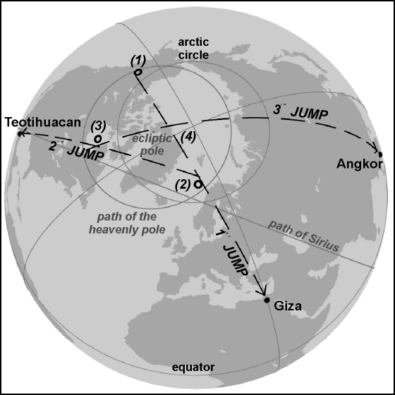
the most recent polar shifting (see pict. 8). Pushed by this extraordinary discovery I wanted to check if also the other two "polar jumps" had any important objective. It did not take long to ascertain that nothing less Giza itself is the objective of the first polar jump, while Angkor in Cambodia is the same thing for the third jump (see pict. 9). The errors are included between 1 and 2 degrees approximately: too small a value to believe simply in a chance. |
Fig. 8 - The Avenue of the Dead of Teotihuacan |
Fig. 9 - The sky-earth globe: shown the "polar jumps" |
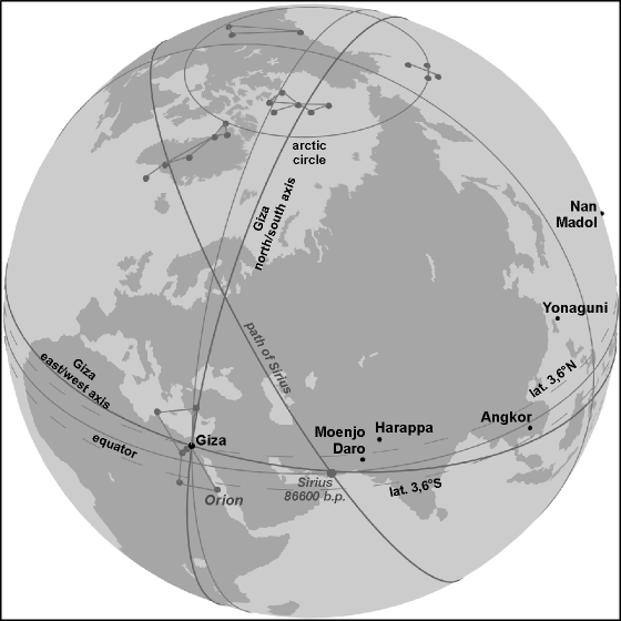
| But these three sites — Giza, Teotihuacan, Angkor — are not but the cornerstones a very world-wide geodetic network, which reveals itself as soon as the order of Earth in the past is examined into details. Let us go ideally in the most remote age, the First Age, which should have extended since 120.000 to 75.000 years ago approximately, when the North Pole was situated in the District of Yukon; during this long period the latitude of Giza, that is today 30° N, was 3,6° N: therefore Giza was situated very close to the Equator, an element surely foreseen by the scheme. All the more so as in proximity of that ancient equatorial circle many of the enigmatic sites of the planet can be found: Tiahuanaco, Machupicchu, Nazca, the Easter Island, Angkor, the Hindu valley with Moenjo Daro and Harappa (see picts. 10 and 11). Even the position of Sirius in the sky-earth globe is coherent with this scheme: in fact the star too, in the First Age, was inside the same narrow equatorial band in which the above mentioned sites were situated. |
Fig. 10 - The sky-earth globe in the First Age (until 80.000-75.000 years ago) |
Fig. 11 - The sky-earth globe in the First Age (until 80.000-75.000 years ago) |
| Conclusions |
| Other correlations come out from the examination of the order of Earth in the Second and Third Age, but at this point we have already collect enough elements to draw some fundamental conclusions. For what purpose the planetary design was devised and realized? In my opinion the answer is evident. The men who accomplished the planetary design wanted to inform the mankind to come respect to events with catastrophic consequences, which took place in the past and which surely shall take place again in the future: the shiftings of the lithosphere. Probably, it was just one of such events to cause the destruction of that antediluvian civilization about which many myths tell all over the world. |
