Maps |
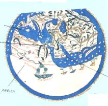
Map of the world (XI century) by Beato di Libebana In the middle ages people
thought the earth was flat and surrounded by a mysterious
ocean. On this map the east is where the north should be. Africa is
called Libya and the Nile runs through it; the Mediterranean Sea is in the
middle of the map. Below the
inscription oriens there is Adam and Eve in the earthly
paradise, the rivers spring from an underground
source |
Map by Edrisi
This is the globe of al-Idrisi, an Arab geographer who lived at the court of king Ruggero. On it are represented Europe, Asia and Africa |
Geographical map of Sicily in XIII century
The map represents Sicily with its characteristic triangular shape; but the cartographer wrongly indicates Cape Pachino as the most eastern cape and Cape Lilibeo as the most
southern one. |
Map
mundi by Hereford (XIII century) In the northern nave of Hereford cathedral there is the map of the world here represented. The scheme with the information of the different places, makes it more legible. It explains how men imagined the world in the XIII century. The shape of the continents and the proportions between the oceans are not very precise, lands and seas. America and Australia were unknown; in the middle there is the Holy Land. Putting Palestine and Jerusalem in the centre of the world coincided with the religious beliefs of the men
of the Middle Ages and with
the geographical experience of that time, the Holy Land was where the three
continents, Europe, Asia and Africa met. |
© S.Lannino 2001