
In order to find
the route in the open sea, the sailors referred to the pole-star, which indicates the
North. If the clouds or some storm did not permit visibility, sailors had to sail blindly.
 The problem of
bearing was solved by the compass, probably a Chinese invention which was brought into the
West by the Arabs and which was commonly used on the
European seas about the year
1300. The compass consisted of a magnetic needle mounted on a fine pivot. The magnetic
needle always points towards the magnetic North. In this way bearing was possible even at
night, in the winter and with an overcast sky. Later, at the end of the Middle Ages, the
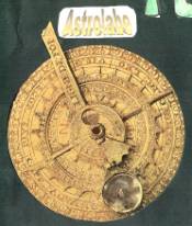
astrolabe was used. It is an instrument already known by the Greeks which the Arabs
improved and spread throughout the Mediterranean. It permitted the measurement of the
latitude of a ship at sea, calculating the height of a star on the horizon. In order to
map out a route, the sailor had the “portolani”. They are nautical maps in which
the line of the coast, ports and landin are drawn exactly.
The problem of
bearing was solved by the compass, probably a Chinese invention which was brought into the
West by the Arabs and which was commonly used on the
European seas about the year
1300. The compass consisted of a magnetic needle mounted on a fine pivot. The magnetic
needle always points towards the magnetic North. In this way bearing was possible even at
night, in the winter and with an overcast sky. Later, at the end of the Middle Ages, the
astrolabe was used. It is an instrument already known by the Greeks which the Arabs
improved and spread throughout the Mediterranean. It permitted the measurement of the
latitude of a ship at sea, calculating the height of a star on the horizon. In order to
map out a route, the sailor had the “portolani”. They are nautical maps in which
the line of the coast, ports and landin are drawn exactly.  There were no meridians and parallels, but
there were some compass cards put in different places of the map. Their directional points extended and
crossed forming a net which represented the maritime routes. These innovations not only
made the navigation safer and faster, but they permitted to shorten the time of inactivity
for the ships during the winter. Streets and bridges were often impassable because of bad
maintenance, consequently navigation was generally favoured. With fair winds people could
cover distances which were unthinkable for people who travelled by land and it cost less.
Contrary winds or dead calm made the voyage endless and painful because sometimes people
suffered thirst.
There were no meridians and parallels, but
there were some compass cards put in different places of the map. Their directional points extended and
crossed forming a net which represented the maritime routes. These innovations not only
made the navigation safer and faster, but they permitted to shorten the time of inactivity
for the ships during the winter. Streets and bridges were often impassable because of bad
maintenance, consequently navigation was generally favoured. With fair winds people could
cover distances which were unthinkable for people who travelled by land and it cost less.
Contrary winds or dead calm made the voyage endless and painful because sometimes people
suffered thirst.
© S.Lannino 2001
