|
S.A.R.
TECHNOLOGY
|
|
WAMM
utilises spaceborne Synthetic Aperture Radar (SAR) images in order to enhance
the calibration of flood forecasting numerical models. SAR imagery is acquired
by the European Remote Sensing Satellites 1 and 2 (ERS-1 and 2) orbiting the
earth with a 35 days repeat cycle, 785 kilometers above the earth surface.
SAR are particularly sensitive to inundated areas and near-surface soil moisture,
and they are therefore well suited for calibrating the extent of flooding
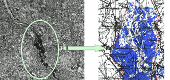
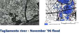
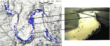
and evaluating runoff coefficients. The images are processed to map the floods.
One image is acquired during the flood event, the other one is acquired without
any flood. The normalized difference image between the two SAR images is calculated
and next classified in order to produce a flood map. In addition SAR images
can be used to estimate the near-surface soil moisture with a precision of
a few percents. FUSAGx's methodology is based on the comparison of SAR image
subsets in different seasons of the year. In the case of unsaturated soils,
the image subsets show a linearly increasing backscattering coefficient value
with an increasing volumetric soil moisture value in the top soil layer. Accurate
results have been obtained using this method in the Lesse basin, with mean
errors of 1.35 % - 2.25 %.
|
| ... |
|
S.A.R.
IMAGE PROCESSING SOFTWARE
|
All
SAR image analysis procedures are elaborated through a software tool developed
by FUSAGx in C++ and running through the Arc-view graphical interface. Since
MIKE11 also runs in this environment, the whole WAMM application will be integrated
in Arc-View. The different steps of the processing were analysed. Some were
programmed in C++ language by FUSAGx (image calibration, image flipping, image
filtering, normalised difference image computation, classified image computation),
others are realised directly using Arc-View Image Analyst functions (image
geo-projection, subset cutting, mean pixel value computation). The software
is now a b-release version and allows the user to map flooding and soil moisture
within a few hours. This tool will be improved throughout the project.
| 
|
|
FLOOD
FORECAST MODELLING TECHNOLOGY
|
|
The
mathematical modelling core of WAMM is based on MIKE11, developed by DHI.
It is however intended to make WAMM applicable to other existing flood management
systems in order to enable its widespread diffusion. The project aims at improving
MIKE11 Flood Forecasting module by answering questions such as: When will
flood water reach a given location on land? How long will the inundation last
/ be more than a given depth? How much could the flooding be reduced by alternative
measures including reservoir regulation, controlled flooding of selected polders,
etc? To reach this goal, the following, new facilities are being developed:
· Facilities to utilise the SAR data on flooding for model calibration and
validation. · Facilities to utilise SAR based estimates of the soil moisture
to improve runoff prediction. Facilities for presentation of the results in
selected points as well in spatial overviews including flood duration maps,
inundation statistics, district flood status mapping, etc.
|