|
The
Innovation Of The Wamm Project.
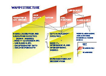
Hydraulic models which simulate overland flow do not usually give accurate
results due to the difficulty of determing the variation of roughness on the
flood plain. WAMM builds on existing river modelling tools and improves its
calibration through the use of Synthetic Aperture Radar (SAR) images and portable
sensors installed in the flood plain. WAMM provides predictions of the duration,
depth and extent of flooding and assesses the consequences of alternative
flood management strategies.
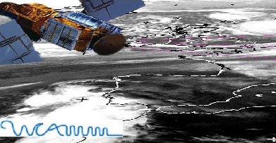
The innovation of WAMM is based on using SAR images to update the soil moisture
data and improve the simulation of runoff during a flood event. An important
advantage of using SAR images, is that they can be obtained at night and through
cloud cover.
|
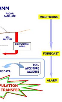
The SAR images are elaborated to provide flood maps and soil moisture data which
are used in conjunction with a Digital Terrain Model (DTM) of the area, for
model calibration and real time flood prediction. Another interesting aspect
of the WAMM project is the utilisation of portable sensors on the flood plain.
The mobile sensors are particularly adapt for their innovative application to
flood monitoring as their small size allows them to be placed in a particular
location, as and when required. The development of WAMM is conducted concurrently
with the pilot studies to ensure integration between research and practical
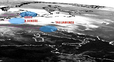
application during the project. The pilot studies deal with the Lesse and Dendre
river in Belgium and the Tagliamento river in Italy. In addition WAMM will also
be used to investigate the potential effects of climate change on flooding.
|
|
Goals
of the WAMM Project.
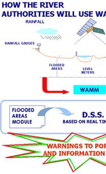
The aim of the project is the development of WAMM, an integrated system of
flood prediction and management.
The WAMM system will provide river authorities, civil protection bodies, ministries,
etc, with the following benefits:
- facilitated flood warning alarms;
- improved management of floods;
- fast and reliable development of flood defence programmes;
- possibility to examine the effect of climate change on flooding.
WAMM will ultimately result as a fully integrated Decision Support System
(DSS), providing the user with the required information, overviews and model
simulations to decide on the best possible line of actions in flood situations
as well as allowing the development of flood warning system that disseminate
flood warnings to the relevant authorities and the public, e.g. flood maps
will be issued through the Internet to fire brigades, civil protection, etc.
WAMM
Key Information
- Start date: July
1998
- End date: July 2000
- Duration: 2 years
- Budget: 836,710 ECU
- Financed under the EC DG XIII Innovation Programme - Technology
Validation and Transfer Projects (36,33% of the total project cost). The remainder
part of the project costs is covered by all project partners, mainly by the
end users, i.e. Italian Ministry of Environment (MA-SIAR), Autorità
di bacino Alto Adriatico - River authority for the Northern Adriatic (adB),
Ministère Wallon de l'Equipment ed des Transports - Service des Etudes
Hydrologiques (SETHY).
|